We had the complimentary continental breakfast in our hotel before leaving at about 8am. Soon we were entering Blue Ridge Parkway. It was a grey morning, but the sun reappeared later on. 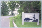
The Blue Ridge Parkway, administrated by the National Park Service, is a scenic road that links Shenandoah and Great Smoky Mountains National Parks, 750 km (469 miles) along the Blue Ridge Mountains in Virginia and North Carolina.
The first portion of the road is surrounded by the beautiful George Washington National Forest. Our first sight, though, was not something pleasant: a dead deer by the side of the road, possibly ran over. Vultures were already feeding on it and flied away as we approached.
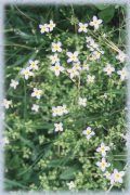
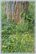 There are many sights along the road, but also places near the road. We decided to take a look in Sherando Lake and it was defintely a good choice! A small road took us there, with a few houses along the way. The quiet lake is used for fishing and boating, and the area round it was very green, decorated with tiny yellow flowers. As it was not the high season yet, there were very few people there. It was a great opportunity for photographs.
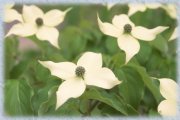
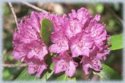
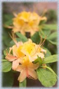
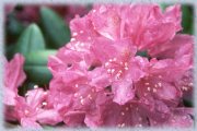
Flowers and more flowers, that's what we found when we stopped in Whetstone Ridge. Rhododendrons and azaleas of all colors - a feast for my camera! I only wished it was less windy.
|
|
|
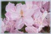
 Soon after, Onion Mt. trail was also a place to see rhododendrons, many of them yet to bloom. Moss and old leaves decorated the tree trunks and rocks. A short but interesting hike.
 To get to Roanoke River Gorge trail, we had to cross the road under a high bridge. In terms of views, it was deceptive - trees blocked the river from the viewpoint. But the easy hike through the forest was very pleasant, including a loop trail where trees are identified. There were busy ants going up and down an oak, carrying leaves and sticks.
We exited the road to have lunch in Roanoke, at Pizza Hut's buffet lunch. It was just past 1pm when we arrived - the buffet would end in half an hour! I even tried one of the sweet pizzas, with rasperry.
Back to the sunny road, we checked Smart View, with an old log cabin and a long trail where we would be able to see dogwood, Virginia's flower, but it was a very long hike - I even tried to find some flowers, without luck.
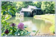 Next stop, Mabry Mill, a lovely wood structure with a water-powered mill, from the begining of this century. You can see demonstrations and exhibits about milling. The griding wheels on display there are so big! In Groundhog Mountain, there is an exhibit about fences. A small tower allowed nice views from the area. Unfortunately, many tourists have this strange need to carve their names on wood, spoiling the original construction.
Small farms, with barns and cattle, are a constant in the roadside of southern Virginia. By the end of the afternoon we entered North Carolina, after around 350 km (217 miles). We chose the small town of Sparta to stay the night. On the main road, we saw a family-run restaurant. We arrived there 10 min before their closing time, 8pm - one has to be careful not to find himself without a meal! It was windy and forecasts were of storms - we could hear the thunders.
Day 4 - "During the day, the sun tried to come out, but it was mostly cloudy."
|
|
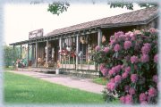
After a few stops at overlooks, not very exciting due to the still wet weather, we stopped at Northwest Trading Post, with lots of souvenirs and handmade articles. It was interesting to see them and the homemade jams were temptating, but I only bought a delicious brownie and two postcards.
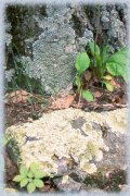
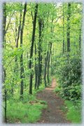 Jumpinoff Rocks was a pleasant trail in the woods, with trees and ferns and flowers - a little muddy due to previous night's rain. As we had no idea of its extension - there was no information board at the trailhead - at some point we decided to turn back. I think we walked there for abour one hour
Linn Cove viaduct has a visitor center, but there isn't much to see there, unless you are interested in the viaduct itself. It was so grey and windy there! We made a quick stop in Linnville, where I mailed postcards while Ernani had a coffee. 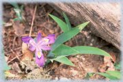
We were then in the heart of Pisgah National Forest. Linville Falls was our next stop. There are three trails branching from a single trail. The first, closest to the parking lot, is easy and only 800 m (0.5 mile) far, allowing a view to the upper falls, about 4 m high (13 ft), dropping to a lake and then to a rocky river.
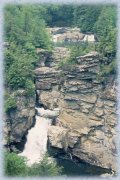 Ernani didn't follow me on the second trail, about 500 m (0.3 mile) farther and a bit harder. From two distincts overlooks, we can see not only the upper falls, but other falls about 15 m high (50 ft) and a gorge downriver. I skipped the last trail and rejoined Ernani near the parking lot. There is also another trailhead on the other side of the parking lot, which we didn't tried - it was a long one, if I remember it right.
While I visited the small but well organized Museum of North Carolina Minerals, Ernani did some phone calls. We next stop in Little Switzerland, with a Swiss-style hotel and a few shops. We stopped for a snack, where I had homemade icecream (good, though not great). A dog seemed to like Ernani and sat by him while he had a sandwich.
It was getting late and unfortunately we had no time for hiking to Crabtree Falls. We also passed by Mt. Mitchell State Park entrance. Mt. Mitchell, 2037 m high (6684 ft), is the highest point east of Mississipi River. Near Asheville, we left the parkway and headed to South Carolina, where we spent the night with a friend of Ernani's.
Day 5 - "So there we were, enjoying the road, when we found a blockage, because there was a risk of rock slides. We would not be able to drive the whole Blue Ridge Parkway!"
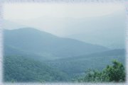 We returned to Blue Ridge Parkway in the end of the following morning. The approach to the mountains is very beautiful, slowly going uphill. It took us more than we had expected, because there was a lot of road work in Hendersonville.
There was sun sometimes, but is was mostly cloudy, and it was warm. The road there goes through a series of tunnels, about eight in 10 miles. Nothing new about the panorama of mountains and forests.
 Right after Devil's Courthouse, a surprise. The road was blocked, still under work, which was supposed to have been finished days before. We would miss the highest point on the Parkway, 1843 m high (6047 ft). Later I learned that, as expected, there is a board indicating that mark - one less photo!
But we were not completely unlucky. We decided to go south and visit Nantahala Forest, about which I had read good things. The scenic byway going down the mountains through the forest was indeed a pleasant trip.
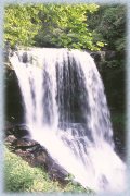
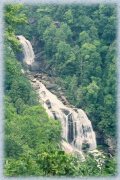 From Saphire, we took the road to Whitewater Falls, near the border between the Carolinas. These falls, 134 m high (441 ft), are the highest east of the Rocky Mountains. There is an easy path to an overlook from where you can see them very well, but there is also a trail, not very well marked, leading to the river upstream to the falls, but you don't get to see much from there. In fact, you need to leave the path and hop some rocks into the woods to get near the river. The water was not very cold, I observed.
Still in Nantahala, we stopped in Cashiers for a snack. It was 2:59 when we got to a Hardee's and it was closed! Most places, we soon found out, closed at 3pm! Our only choice was a Subway. Not bad, I had a turkey sandwich. An employee from Hardee's went there too...
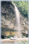 Bridal Veil is another waterfall, 36 m high (120 ft) just by the road and you can drive under it! Of course almost every tourist stop there for a picture. We were no exception.
 Then we stopped to see Dry Falls, only 23 m high (75 ft), whose greatest attraction is that you can walk under it without getting wet. So they say, because we were not allowed (well, sort of...) to do so due to works, nor I believe, for what I saw, that the spray from the falling water cannot reach people walking under the rock. It is beautiful, nevertheless.
The Lower Cullasaja Falls, 76 m high (250 ft) can be seen from the road, but there is no pullout for a better view. There are other falls in this region, some reachable only by long hikes, like Glenn Falls. Highlands is a pretty town with shops and hotels, the nicest place we saw there for those who want to overnight in the area.
But we went north to Waynesville, closer to the Blue Ridge Parkway. It was not easy to find a hotel for a low price - it was the start of Memorial Day weekend. We had dinner at Quincy's. My choice was a grilled chicken brest with vegetables, plus a not very exciting dessert buffet.
Next morning we drove the last miles on Blue Ridge Parkway, before entering Great Smoky Mountains National Park. But this is for the next part of my report.
text and photos © Maria Adelaide Silva
no reproduction is allowed without the author's agreement